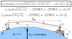
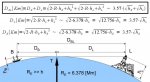
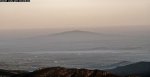
Let's see if we can get it right: The camera is at the shore of the island looking toward Perth, and is 3-4 meters above sea level? In post#7, the topographical guide underneath the picture shows parts of Perth 20-40m. The picture in post #4 seems to show only the buildings abouve 2 stories. I cannot see any less. That adds about 5 meters. The vivsible part of Perth in the picture is thus at least 25-50 meters above sea level. The formulas are 3.57(2+5)=25 km for the lower parts of Perth, 3.57(2+7)=33km for the parts on the higher hills. That exactly agrees with what we see. (Light refraction can make it 3.86, not 3.57, adding an extra km or so). The picture at 28km shows the top of the first storety buildings, because the horizon blocks anything under that. If you care to spot a particular landmard on the outside of a particular skyscraper, and get me the height above sea level and the height of the mark on the building, we can prove the formula even more exactly.
If the earth were concave, not only the first storey of all buildings would be visible, but you could see all the land from the shore up to the front door of those buildings in the photograph also.
If the earth were concave, not only the first storey of all buildings would be visible, but you could see all the land from the shore up to the front door of those buildings in the photograph also.
Horizon calculator - radar and visual
here, add 2 or 3m first where h1 is.
You can see the other side of Perth, the hill from almost its base. See diagram in post 7.
Last edited:
")